1a. Site Observation
(1) Site Conditions
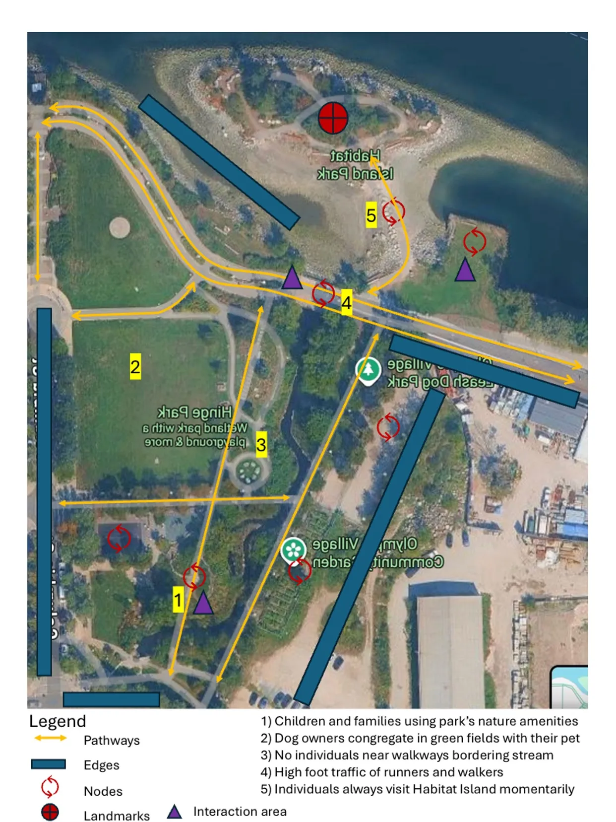
The Habitat Island and Hinge Park site is mostly unassuming with lots of green space and an intriguing mix of natural and built elements. As a system, it is focused on inviting creativity and recreation through this mix. Hinge Park is located in Southeast False Creek nearby many high-rise, apartment-style buildings on Columbia Street and is bounded on the north end by the seawall. Habitat Island resides adjacent to the seawall, within False Creek. The space emphasizes sustainability. Our observations began on a late Friday afternoon with slightly cloudy weather.
We first noticed the large field area of the park, which was mostly empty save for some dog owners who were using the space as an off-leash area (though it was markedly on-leash only). There are lots of trees and bushes throughout. Distinguished built paths across the fields were used by walkers passing through towards the seawall/Habitat Island or to other areas of the park. These paths tended to have foliage delineating them. Cyclists also used the area as a thoroughfare to reach the seawall. Hinge Park felt streamlined and level, which contrasted the inconsistency of Habitat Island. Some interaction would occur spontaneously among dog walkers, but there were no distinct nodes in that area. There were a few picnic tables on the main green that were unused during our observation. We noticed some kids playing on the playground as well as in the sewer pipe bridge/water pump area—an area that facilitated creativity and interaction with nature. Kids had fun stopping and starting the pump and following it through to its deposit below the pipe bridge.
Additionally, the section to left of the main green featured a dog off-leash area and a community garden. The off-leash area was practically unused, though it could offer spontaneous connection. Rather, as mentioned above, most used the main field area as an off-leash park. The garden supported the value of sustainability and recreation within the park, as it looked lush, well-taken-care-of and invited engagement.
We observed the largest amount of people closer to the seawall. These were runners, bikers, and walkers who were passing through Hinge Park. In our observations, we found that the park did not seem to be a place where people lingered but rather a place that people passed through, stopping briefly for repose. More people were moving around rather than through the park itself and many avoided shadier and bushier areas, perhaps due to feelings of discomfort or suppression. Large stones were used to engineer steps and seating throughout the park, though most seating areas went unused during our observation period.
We saw a few people struck by Habitat Island, which we considered to be a landmark given its visibility and novelty. It has a varied typography with mixed natural elements such as rocks, soil, and grass, alongside many trees. The proximity to the water made the climate slightly more humid and breezy within the island. However, the island itself seemed isolating and unnerving. It had an aesthetic view of the water and skyline but was ridden with litter, which counteracted its intention of creating a haven to promote the health of different species. The large trees made the island seem darker and shadier than the rest of the site. Of the people who stopped by Habitat Island, most entered it briefly and did not stay there long. On the main field of the park, we had observed a rezoning notice to build an elementary school in the park. While the park seemed to attract kids and young families, the proximity to Habitat Island could generate risk due to misuse of the space within the island.
(2) Asset/Vulnerability Map
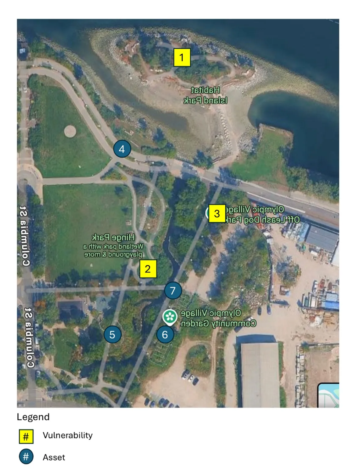
| Map Number | Asset/Vulnerability | Description |
|---|---|---|
| 1-Habitat Island | Vulnerability | It was not very approachable and was littered with beer cans and graffiti. In this way, the island felt like it was not following the planners’ intention of creating a safe space for plants and species. The litter also discolored the island’s core value of sustainability as it harms the environment. |
| 2-Nodes | Vulnerability | The nodes were meant to facilitate interaction but went unused during our observation period. |
| 3-Off-leash area | Vulnerability | The unused off-leash dog area could be developed to create more space to engage with the natural and built environment or to have more installations that reference the neighborhood’s historical industrial heritage. Perhaps the appeal of the main field as an off-leash area is its abundance of greenery, so the official off-leash area could benefit from the addition of grass. |
| 4-Path to seawall | Asset | The path through the park to the seawall was heavily pedestrianized and used by many bicyclists. This gives rise to lots of foot traffic that nurtures the social aspect of the park. |
| 5-Playground+bridge/water pump | Asset | We thought this was a successful example of ways the park facilitated engagement and creativity while also promoting its value of sustainability. The water pump, specifically, exemplifies the park’s use of natural elements to generate interaction. |
| 6-Community garden | Asset | The community garden not only aids the park aesthetically, but it also represents social and environmental aspects. Community gardens show off local flora and fauna while also advocating for sustainability (through growing food) and community spirit (by inviting the community to contribute). |
| 7-Bridge | Asset | Finally, we appreciated the bridge across the water within the park that looks out towards the seawall. We noticed many people stopping at the bridge to absorb their surroundings and thought that it successfully encouraged human interaction with other people and the environment. Thus, this strengthens the environmental and social impacts of the site. |
1b. Background Research
Habitat Island and Hinge Park express some of the strategies in the SEFC Public Realm Plan. Probably one of the most successful outcomes is its development towards being walking- and bicycle-friendly. During our site observation, we noticed many people cycling through, and the pedestrian paths made it easy for us to walk the entire park. Additionally, we noticed community gardens; this, alongside the fact that the part itself is a wetland, follows the planners’ intentions of exhibiting sustainability. There was a playground and a dog run that contributed to the goal of creating a mixed-use and accessible space. We especially liked the industrial pipe bridge and the water pump with ramps leading to a creek. The bridge helps remember the area’s history as an industrial yard which aligns with the goal of preserving the heritage of the space. The water pump created interaction and brought more natural elements, again tying in the theme of sustainability.
However, our observations also showed us ways the goals of the Public Realm Plan were not met. First of all, there were a few spaces that did not seem to cultivate human interaction in the way the planners intended. There was a secondary node that provided seating and had paths going to main walkways (to the waterfront and to the main area of the park) that seemed to be mostly unused. Additionally, the plans outlined ideas of Habitat Island as a “community park”. However, we found Habitat Island mostly unpleasant and unapproachable. There were litter and graffiti, which interrupt the Island’s intention of being a natural haven for nurturing diverse species. Its shady inside space was also not very appealing. The plan also framed the neighbourhood as having a distinctly industrial feel, something we did not notice much throughout the park (besides the pipe bridge, which felt hidden within Hinge Park). Finally, while there were a few people using the dog run, it was mostly empty. Ironically, we noticed many people using the main grassy area of the park (indicated by signage as “on-leash”) as an off-leash area. Thus, there may need to be some focus on utilizing the spaces in a way that both aligns more with planners’ values of sustainability and community but also with the way people are already using these spaces.
1c. Census Mapping
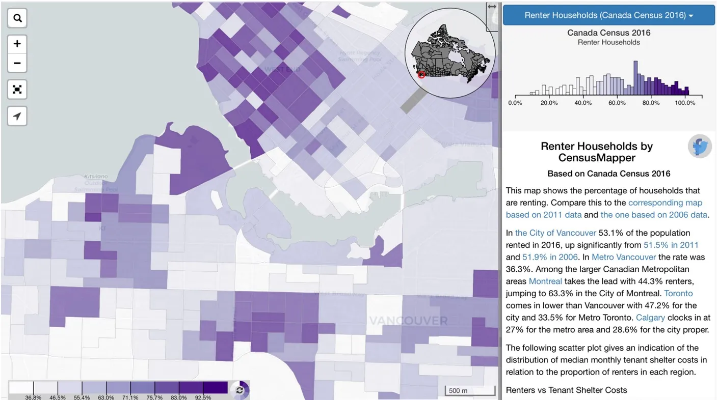
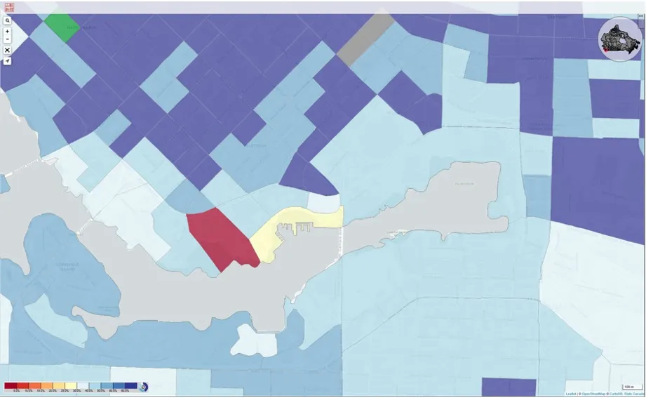
The first map is focused on measuring the amount of renter households within each area. Just under 50% of housing in the SEFC area is renter owned. While this is a much smaller amount compared to denser areas like Downtown, it is comparatively more than the majority of neighborhoods deeper inside the city. During our site observation, we noticed lots of high-rise buildings around Hinge Park and Habitat Island. This can help inform why there are so many renters in the area, as the high-rises are mostly apartment buildings. The non-renters could be owners of family housing, which is emphasized in the SEFC Public Realm Plan. It is important that parks and recreation spaces in the SEFC are in conversation with the local community demographics. Most people in renter-owned housing are in apartments, meaning they do not have amenities such as yards or gardens. Parks like Hinge Park can effectively fill this gap by providing green spaces that are open to the community. Those with single-family homes look for space for kids and pets to play, which the parks also provide. With more care, Habitat Island can become a welcoming environment for children in the neighborhood. Its mixed use of natural elements creates interest and invites engagement. However, it currently is littered with trash and graffiti which may not be as inviting.
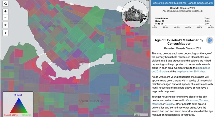
The second map shows the age of the household maintainer. SEFC is shown to have a much younger population (with most people being 54 years old and below) compared to other areas of the city, as denoted by its green color. It would make sense that a younger population has many people renting rather than owning homes, as over time, housing costs have increased making it harder for young people to afford to own a home. The addition of more multi-family, rentable housing can improve the site to support the large amount of young people in the area. Additionally, the majority of people living in SEFC are below the age of retirement. The location of this neighborhood adjacent to downtown probably allows young, working-aged people to commute to work in the central business district easily. Young families can benefit from green spaces and playgrounds in SEFC where kids can play and participate in recreational activities. Perhaps the implementation of amenities such as co-working spaces can foster more connection among young people who may be working remotely post-COVID. Outdoor fitness equipment (pull-up bars, parallel bars, basketball hoop, etc.) within the parks could be beneficial for younger and older people alike. This should be developed alongside the cultivation of large, tall trees that can provide shade.
The third map shows the amount of people who walk and bike to work. In SEFC, around 40% of people use active transportation to work. This is similar, if not slightly less, than rates in the surrounding area. To respond to this, planners could prioritize creating lots of bike parking and a novel and visually appealing landscape. Public art installations and abundant lighting can create a welcoming environment for those who commute at a slower pace. Lighting is especially important to ensure the safety of those commuting during the nighttime. Public art in SEFC can be focused on installations that reference the area’s industrial history, as outlined in the Public Realm Plan. Wide pathways integrated within local parks and along the seawall encourage people to walk and bike more while also accounting for aesthetics, further creating a more pleasurable commute. Paths should be fairly even and there should be abundant benches for rest along the way. Hinge Park does a suitable job with this although there are a few slim, shadier paths that seemed less inviting for people to walk through.
In conclusion, green spaces in SEFC should be maximized so that they can be of the utmost use to the local community. This is a community of renters and homeowners, people below retirement age, and of many people who walk and bike to work. Thus, planners can consider implementing more infrastructure that appeals to those without in-home large natural spaces, that allows young people to interact, and that promotes a more gratifying commute.
1d. Link with Early City-Making
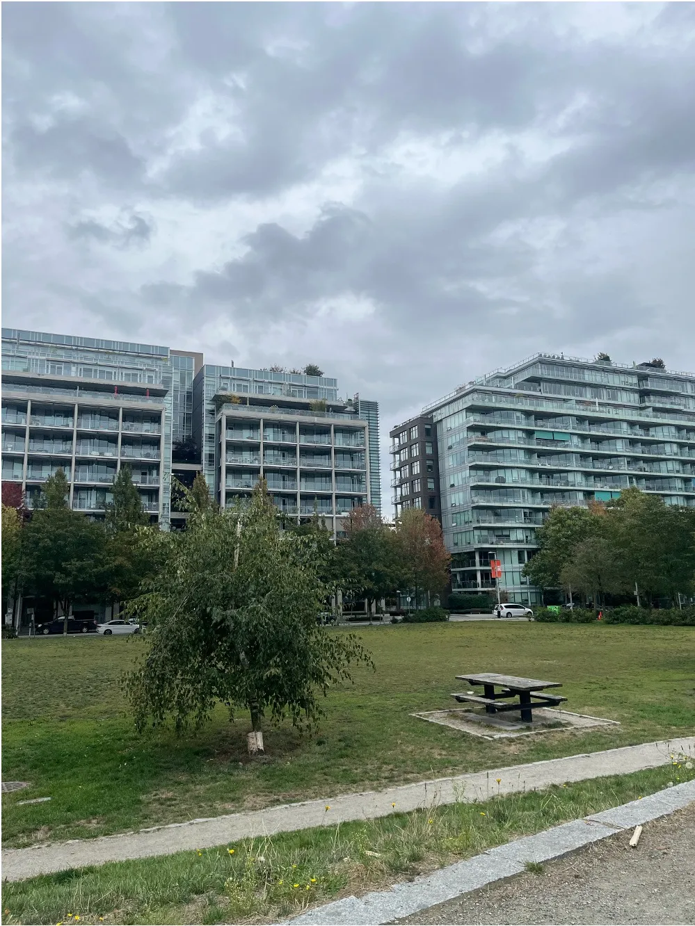
This is related to the idea of building a public realm during Greek and Roman times. This is because both groups emphasized creating places of public gathering and interaction in order to advance the creation of culture and community spirit within the city. Greek cities, specifically, built an “Agora” as the “heart of the city”. These were places where people would gather to catch-up, exercise, shop, and debate. These spaces were not only for entertainment and interaction, but also for civic participation. A few key aspects of the public realm are ensuring that people are free to pass through, without having to actively interact with others and that a space is not overly defined. Richard Sennett argues that anonymity and passive interaction is beneficial for individual personality development among people who may share different identities and perspectives. He also says that having spaces that are overly determined and created with rigid functions in mind can lead to urban decay. People should be able to define public spaces as they are used over time.
Habitat Island and Hinge Park are similarly meant to encourage engagement among park-goers through large green areas. An aspect of creating a good public realm is ensuring that people can define a space over time through repeated use. Large, empty fields can be used for many different activities that encourage individuals to gather. During our observation period, we mostly noticed dog-owners letting their dogs run in this area, but it is possible that the field can also be used for sports practice or picnics in warmer seasons. Aspects of the park that encourage interaction between people and the environment also help represent the public realm comparably to ancient cities. The sustainable values of the area encourage like-minded people to gather and interact with each other, as strangers or otherwise. Finally, the multitude of paved roads within the park encourages people to pass through, passively gathering information on others, which can strengthen local culture.